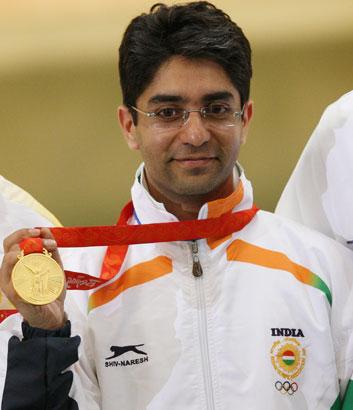
1. 28 years later, Abinav Bindra wins a Gold Medal for India at the Beijing Olympics in 10 meters air rifle event. The first ever individual Gold Medal for India. A long wait for national anthem to be played at the Olympics, but an amazingly nice feeling.

    Heartiest Congratulations Abinav Bindra !!!


    Image Courtesy: www.Rediff.com

    1

    View comments

  2. Reminiscence has been tagged by The Resurrection. Lately I have been quite lazy to write up something or other, so... here's a chance to write up another post.

     Last movie seen in a theatre?
    Ugly aur Pagli (what a movie!!!). Wonder where these people get idea to make such movies.... hats off.. and I go and watch that.

    What book are you reading?
    "The five people you meet in heaven" by Mitch Albom.

    Favorite board game
    Scrabble

    Favorite magazine
    Not much a magazine reader. These days, any photography magazine (online). 

    Favorite smells
    Smell of the earth after it rains.

    Favorite sound
    Sound of instruments.... the sound of the Guitar.

    Worst feeling in the world
    Being really lonely.

    What is the first thing you think of when you wake up?
    How to spend today? Why can't I just lie and be at home doing what I like best.

    Favorite fast food place
    Pizza Hut.

    Future child's name
    Hmm....

    Finish this statement. "If I had a lot of money I'd..."
    be traveling places and photographing.

    Do you drive fast?
    Yes. I want to but for these Bangalore roads... and traffic.... Maybe if i had money I would build roads just for me.

    Do you sleep with a stuffed animal.
    No.

    Favorite Drink
    Kalmane Coffees.

    Do you eat the stem of broccoli?
    No.

    Storms - Cool or Scary?
    Cool. I want to feel how it feels to be feeling it.

    If you could dye your hair any color, what would be your choice?
    Dark Blue!

    Name all the different cities/towns you have lived in:
    Nagpur; Indore; Delhi; Chandigarh; Masoorie; Kota; Madhopur; Pune; Bangalore; (If I take liberty to add cities I have been the list would be huge)

    Favorite sports to watch
    Any, but still Formula 1.

    One nice thing about the person who sent this to you
    Over cautious but fun to be with.

    What's under your bed?
    The floor! Nothing, absolutely

    Would you like to be born as yourself again?
    Yes, with the voice of Sonu Nigam.

    Morning person or night owl?
    Nocturnal. Early riser only if a game of badminton or cricket or trek.

    Over easy or sunny side up?
    Easy!

    Favorite place to relax
    My Room.

    Favorite pie
    Chocolate Fudge

    Favorite ice cream flavor:
    Not fixed, the dish that comes with maximum ice-cream :)

    You pass this tag to:
    Ajit, Milind,

    Of all the people you tagged this to, who’s most likely to respond first?
    Ajit Oke.

    0

    Add a comment

  3. 19th July, 2008.
    Route: Udhampur – Pathankot – Delhi.
    Distance Covered: ~110km by bike, 476km by train.

    The easiest day

    There are two routes from Udhampur to reach Pathankot, one via Jammu and another via Surinsar mansar wildlife sanctuary and dayala chak. The other route via Dayala Chak is a short cut, it is not as good as NH1, but still in better condition. The journey from udhampur to pathankot was uneventful. We reached Pathankot somewhere around 12pm, searched for the GATI courier and cargo. Just after reaching Pathankot, my bike’s fuel got empty, the last petrol filled was in Leh, it gave an amazing mileage; from Leh to Pathankot in one full tank. By the time all the formalities are complete, it was around 3.00 pm; we booked train tickets to the Delhi, had late Lunch and back to the station. Tonight was to be spent in the train.

    We would be in Delhi tomorrow.

    ----------


    20th July, 2008.
    Route: Delhi – Bangalore.
    Distance Covered: 2061km

    The last day.

    Reached Delhi, First time we were not driving after so many days. Felt nice. Took a metro to Dwarka Sector 9, took cycle rickshaw to reach my sisters place. Spent the afternoon at her place. The flight to Bangalore was at 4.30pm. Sudhakar, Shantanu and Manoj went to a hotel and later they were roaming in and around cannaught place. They managed to miss the flight :) They got another flight back to Bangalore somewhere around 9pm.

    Thus the hectic last 16 days came to an end. One has to visit Leh-Laddakh once in his life. It’s very beautiful. The most surprising thing that happened was we never encountered a situation where we were struck; the people are very friendly. We never had a single bike problem, not even a puncture. Most of the people have told us that falling from the bike, burning of the brakes, punctures are a common occurrence but we did not encounter any of it.

    If you ride safe and preferably take your own bikes with disk brakes, you would not end up in problems. We met many people who had rented bikes ended up in problems.

    We used all possible modes of transport in this trip, flight, train, metro, auto-rickshaw, cycle rickshaw, bikes, public taxi, private tourist vehicle and of course walking.


    2

    View comments

  4. 18th July, 2008.
    Route: Srinagar – Jawahar Tunnel – Patni Top – Udhampur.
    Distance Covered: ~230 km

    The relaxed day.

    The morning was lazy. We decided to go for sight seeing in Srinagar for the first half of the day, went to Shankaracharya temple. After heavy breakfast, we packed our luggage, and started from Srinagar by 12pm. We were told that the roads are in such a good condition that we could reach jammu by 6 hours, we took another 2 hours as grace period. Idea was to reach Jammu by 8, a distance of around 300km.

    The traffic on the Srinagar – Anantnag – Jammu highway is a mess, people do not seem to have sense of when to overtake and when not. Cabs, Bikes, buses, trucks all trying to overtake each other, from our direction and at the same time from other direction. The inter city buses are the worst, they drive right through the center at the slowest speed rarely allowing you to overtake and worst stopping abruptly for some passenger to alight. The truck drivers are next; they will not allow overtaking easily. Often you will end up in race to overtake.

    We crossed huge convoy of pilgrims going to Amaranth Yatra on the way. The Jawahar tunnel kept going on and on and on. It is almost 2.4km long; it is unique in way; it has emergency exit gates every 100 mts, and phone booths every 200 meters. The Tunnel is a high security zone; there are check posts before entering the tunnel.

    The traffic had stopped some 10kms from Banihal. Initially we thought of some security check post as there were lots of army personal around. Later we realized there had been bomb blast at blast at Banihal. Security guards allowed us to go ahead, all the 4-wheelers were stopped are checked thoroughly.

    The highway from Srinagar to jammu is completely a ghat section. Its downhill until we reach jammu. Though road was in good condition, it was clear that we would not be able to reach jammu by night. Somewhere after crossing Patnitop we stopped for a quick tea, and decided to halt at the nearest town Udhampur.


    0

    Add a comment

  5. 17th July, 2008.
    Route: Kargil – Drass – Zozila Pass – Sonamarg – Srinagar.
    Distance Covered: ~204km.

    The day of remembering Kargil war heroes.

    We started early morning from Kargil at around 7am; thankfully breakfast was included in the room rent. The plan was to reach Srinagar by evening, considering the road we have had been on the previous day we had no hopes for good road today as well.

    The scenery was becoming more and more greener as we were moving further. After crossing Kargil, we saw sign boards on the road that read “Careful, you are under enemy watch” and then at places high walls, made of rocks and secured by metal nets, along the road. We reached place called DRASS, the 2nd coldest place inhabited in the world. It has Kargil-war memorial. One has to embark upon such journey just to get feel of what cold harsh conditions the solders at the Indian borders might be undergoing; and this was summer. The solders there were eager to show around the war memorial, tell stories of the Kargil War, showed us the famous Tololing Hill, Tiger Hill, Rhino Horn and many more posts of prime importance where India fought war with Pakistan in 1999. The tololing hill is a huge hill and one can see almost 35km of national highway from the top, hence those signs “enemy watch” were put up on the road during the Kargil war to alert army convoys passing through. Few solders were painting letters engraved on a board at the war memorial that told story of the Kargil war; they allowed me to paint few words.

    The roads were never better, somewhere during noon we reached Zoji La Pass, at an altitude of 11570 ft (not much compared to the previous passes we had crossed so far) this pass was unique. On one side was the high mountain carrying the narrow road that brings one to this pass, other side was a deep valley. There were huge green mountains of Sonamarg on the other side. The most beautiful mountain range and scenery we had seen so far on a mountain pass. We realized why Kashmir is called “Heaven on the Earth”. Sonamarg is an amazing place, Himalayan scenery at its best. The roads are narrow that trucks go in only one direction in the morning and another direction in afternoon. Zozi La Pass has the steepest and the worst descent I had seen so far. The road had already disappeared; the gravel and loose sand coupled with uneven rocky patches had taken its place. To add to the difficulties, we had to ride in 1st gear, no accelerator and with continuous brake applied. The 8km descent of Zoji La ranked worst of all passes on Manali-Leh-Kargil-Srinagar route. One slight mistake and you are 1000’s ft down in the valley; there is absolutely nothing between.

    Descent from Zozi La brought us into the Kashmir valley. Sonamarg was the most beautiful town I had ever seen, huge mountains, greenery all over the place, river flowing in the valley, clouds hanging in the air, mist and snow capped peaks. Almost everything an artist/painter could imagine. We took a short informal break just to look at the scenery, forgot about all problems Zoji La posed during the descent. From the Zoji La top we had seen colourful tents in the valley, many, in fact the valley was completely filled with tents; later we realized Sonamarg is the base camp, and these tents were for the pilgrims, of the Amarnath Yatra. We stopped at Sonamarg for Lunch. It was around 2.30pm.

    Driving from Sonamarg was a breeze, it continued for the remaining distance. We reached Srinagar by 5pm. We settled into a house boat in Dal Lake. It was the most luxurious stay of our trip and of-course the costliest as well, roamed in Dal Lake on shikara. Ever since we left from Kargil there had been steady security along the road, it increased as we entered Kashmir valley and in Srinagar there was a CRFP or J&K Police was standing guard every 50 steps. The plans to start early tomorrow were abandoned; the trip was coming to an end. Today was the evening to relax, the first after many days.


    4

    View comments

  6. 16th July, 2008.
    Route: Leh – Nimmu – Lamayuru – Kargil.
    Distance Covered: ~230km.

    The day of return journey.

    After been to the Nubra Valley, we were bit sad as we could not see its other end ‘Sumur’ and ‘Panamic’ again the last points but on opposite bank of the river Nubra/Shyok. On the other hand, we had to start today with one day kept as buffer for unforeseen problems. The plan was to reach as much distance possible and try to reach Kargil by evening, a distance of 227-230 km from Leh. We chose to return via Kargil-Srinagar route, as most of the locals told that this route is in far better condition that Leh-Manali route.

    We filled up petrol tanks, and were literally cruising (60-70kmph; sometimes 80kmph) on the Leh-Kargil highway. At some places the bike literally drags; even though the road appears to be downhill. Later we realized that we were passing a place called magnetic hill. It is said that if you park your car on the road and keep it in neutral, it will start rolling in the uphill direction of the road; that explained why our bikes encountered drag. According to wikipedia, the landscape, because of an obstructed horizon, creates an optical illusion where an uphill road appears to be downhill.

    Indus River kept us company almost throughout the route. After 25kms into the route we reached gurudwara called Pathar Sahib, stopped here, took the blessings and Prasad. It is believed that Guru Nanak had been meditating here when a demon tried to kill the Guru by rolling a large pathar (boulder). The boulder came rolling down and when it touched the Guru’s body it came to halt. The Guru remained unhurt, his back, shoulders and head left an impression in the boulder which can be seen. Also demon’s foot impression can be seen on the other side of the boulder when he tried to kick the boulder. The place is now maintained by Indian Army.

    The road continued to be in amazing condition, met an Army convoy and overtook them this time quite easily. We reached a village called Nimmu and decided to halt for breakfast, it served the best paratha’s in the complete trip. After Nimmu, the road condition deteriorated and immediately few km later the road almost vanished, a dirt track, gravel track and under construction mountain road took its place. We continued in the hope that this patch would get over soon but not. The day was marked for riding on the worst road of the trip. Nimmu-Kargil was easily the worst road of the entire trip, often replaced by the dirt and fine sand. However it offered beautiful landscapes.

    After am hour or so, we met with an incoming army convoy. Passing that was not easy and as soon as we passed that we were struck behind another huge army convoy going probably to Kargil. The roads became narrow and overtaking this convoy was not easy. We followed them for most of the time and by the time we reached Lamayuru we had overtaken them. At Lamayuru, we had a confusion amongst us for the first time. Manoj and Sudhakar had actually stopped for Lunch and were waving hand to stop, while I thought they told Sudhakar told me to continue further so that we are not again get stuck behind the convoy. Later when I realized, in spite of madhavi telling me to stop, it was too late. Manoj in a fit of rage had gone much ahead and all we had to do was continue riding ahead until we reached next town/village.

    As we crossed ‘Fotu La’ (at 13,647 ft, is the highest point on the Leh – Srinagar Route) the landscapes were getting prettier and greener. The decision of not having Lunch at Lamayuru was not a good idea; we never found a decent place to eat until we finished the day. Somewhere during late afternoon I suffered first half fall; actually not a fall exactly but the foot deep fine sand, which I could not see because of dust blown by Shantanu’s bike riding ahead, had caused me to loose balance a bit. As the speed was slow and with disk brakes, I managed to stop the bike just in time and prevent from falling it. We crossed Namika La pass on the way.

    We were bit tired when we reached Kargil; the NH1, Leh-Srinagar highway, had taken its toll on our bodies. We stopped at the first Hotel we found, Hotel D’Zozila at Rs1000 a day/per room was not worth the price it commanded.

    Srinagar was still 204 km apart, and Delhi 1080 km’s.


    2

    View comments

  7. 15th July, 2008.
    Route: Hunder – Diskit – Khardung La – Leh.
    Distance Covered: ~126km.

    The day of camel safari.

    After another lazy start to the morning, we were at the Dosa Corner canteen operational in the Army base at Hunder. Had a round of Dosa’s and Idli’s after so many days of eating Butter-Toast, Maggy and Parathas.

    Hunder, a small village in Nubra Valley, is the last point in Nubra Valley where tourists or visitors are permitted. Beyond this point is the army area, the valley further leads to Siachen, the world’s costliest and highest battlefield. Hundar is one of those rare places on earth where you can see in one place the splendid beauty of a desert with Bactrian camels (two-humped), sand dunes, rolling mountains and snow peaks. We reached hunder by 9.00 am; spent some time took some snaps and then it was time to move on. All of us except Madhavi took camel safari. Madhavi wanted to have her snap taken riding a camel but before she could seat on the camel properly, mary, the camel got up; madhavi had a mild fall. My camel called dum-dum was the laziest camel while mary, the only female Bactrian camel, was always in the hurry. The day and experience ranked one of the best in the trip.

    When we were returning from the Diskit monastery, we saw a kid dancing on some laddakhi song and a person video recording it. The plan was to reach Leh as soon as possible and ride non-stop, except lunch break. We were riding at much higher speeds, partly we had seen all these roads while coming to Hunder and partly the weather was too hot today. Somewhere on the way a guy riding a scooter overtook all of us; but more or less remained in reach with the group; we were surprised to see somebody riding scooter so fast on such roads. Scooter is the most preferred 2-wheeler of the people around the Leh region(because of stepney).

    The check posts at Khardung La are called North Pullu and South Pullu. The climb to the Khardung La, while returning from Hunder is from the North side, we reached Khardung village and decided to stop for lunch. The guy, riding scooter along with us, also stopped, later, after introductions, we realized that the guy is actually a lyricist, singer, music director, music video director, and producer of Laddakhi songs called Thinless Dorjai. Later he took few video shoots of us riding on Khardung La.

    The climb this time was little difficult as the road from the north side is worst and to complicate matters further we met the army convoy coming from Leh. As if this was not enough we met another army convoy after crossing the one coming from Leh, this going towards Leh. It meant riding behind the Convoy on the watery roads (result of melted ice because of hot day) of climb to Khardung La pass. Riding behind the slow moving, thick smoke emitting army convoy is not easy. Though army people had been helpful through out the tour so far, when it comes to convoys they do not give side to overtake so easily on the mountain routes. We managed to cross convoy at the top and started immediately, without spending much time at the top, as it would have meant riding behind the convoy again; anyway's we had to again overtake nearly 20 more army trucks on the downward journey to Leh. We directly stopped at a place 8-10km from Leh where an army truck had fallen in the valley few hours before. The way that truck was crushed, it was a horrifying site. We reached guest house at Leh by 5pm.

    After evening snacks at the German Bakery, roamed in the Leh market, Sudhakar and Manoj did last minute shopping and returned to the guest house.

    Tomorrow would be the day of return journey.


    3

    View comments

  8. 14th July, 2008.
    Route: Leh – Khardung La – Khalshar - Diskit – Hunder.
    Distance Covered: ~126km.

    The day of driving on the world’s highest motorable road.

    We got up late in the morning. The permits were to come by 10-10.30am. After lazy morning and heavy breakfast we started for KhardungLa at around 12 noon, partly because of delay while obtaining permits; the owner of our guest house was the most worried man for our permits. The bikes were lighter as all our luggage was at guest house, the plan was to cross Khardung La and try to reach Hunder by daylight. A distance of 126 km.

    The road to Khardung La from Leh is in good condition; the bikes were traveling at an average speed of 35-40 km on the ascent of KhardungLa. It is advised to start the climb to KhardungLa early in the morning in order to beat the slow moving army convoy. We started much later, the convoy had already gone. There was absolutely no traffic on the road to KhardungLa. As we were climbing up the landscape was changing constantly, more and more mountain peaks were joining the view, and the snow capped mountain range at far distance was looking stunning. The final few km of the ascent are in bad shape, otherwise the road is well maintained.

    KhardungLa, at an altitude of 18380ft is the highest motorable mountain pass in the world. Spent some time at the top, it was certainly cold at the top but the newly purchased riding gloves at Leh had done their work of keeping the cold out. It was much easier as compared to Baralach La under similar conditions. Had hot black tea at the army operated canteen at the KhardungLa top; took some snaps and started for onward journey.

    The descent or rather the road on the north side of KhardungLa is worst, the south side that is towards Leh is in much better condition. Hunder and Panamic, part of Nubra Valley, are the last points in India where tourists can visitl; beyond that only army personal and locals are allowed. Hunder is cold desert in the Himalayas while Panamic has hot water springs. Both of these places are very beautiful, the landscape along the route is changing continuously every few kilometers. The roads were in good condition after we crossed Khardung village. Somewhere near Khalsar the weather changed a bit, became rainy, slight drizzle and again back to sunny. We got to see rainbow here, a complete semi circle. The landscape is at its best from the Khardung village onwards, changing from arid desert to a small oasis.

    We managed to reach Hunder by 7pm, a small village amidst fields of rye, barley, fruit orchids and sand dunes. We decided to spend the night at Hunder at the only available guest house. The scenery was not visible in its full glory as it was late evening time, which we were to appreciate the next morning.


    0

    Add a comment

  9. 13th July, 2008.
    Route: Leh – Karu – Chang La – Pangong Tso – Chang La – Karu – Leh.
    Distance Covered: ~300km.

    The day of visit to Pangong Tso.

    The Scorpio was at the guest house sharp at 6.30. Since it was quite early, all our caretakers were fast asleep. Rikzik, our driver for the day started calling for us. Sudhakar went to open the doors of the guest house in payjama’s, and rikzik asked him to convey message to the Indian tourists that their Scorpio has arrived.

    We started from the guest house by 6.45am non-stop until Karu, where we stopped for quick breakfast and tea. Sudhakar was in so hurry that we just had tea and decided to pack parathas. The persistent rains since yesterday afternoon meant it was snowing at mountains surrounding Leh. Trouble, if it was snowing at mountains since yesterday the chances of our crossing the mountain pass were nil unless weather changes to sunny suddenly. The road to Pangong Lake goes via the mountain pass called Mighty Chang La. The mighty Chang La pass, at an altitude of 17800 ft, is considered 3rd highest pass in the world after Khardung La and Tanglang La. No vehicles were allowed after the check post as it was snowing at the top. We decided to wait for sometime and see if weather changes; if it changed there were chances of going to Pangong lake otherwise we had to go back.

    Luck was by our side; in half an hour the weather changed suddenly and became sunny and remained throughout the day. The further journey to Pangong Lake was uneventful. Since we were not driving we had lots of time to take snaps and sceneries were really amazing. Reached at the top of Chang La, took snaps, walked on the 1ft snow, had free tea at the army operated canteen, played a bit in the snow and moved on.

    The Pangong Lake is really huge; The Indo-China border passes through it. The lake is around 35 km’s in India and 70 km long in china. The water is crystal clear and blue in color, it actually changes its color as the sunlight changes, from green to blue to deep blue to grey. The lake has a calming effect; one can just stare at it for hours; it’s the most beautiful lake I have seen. It is perhaps the highest salt water lake in the world.

    Another day came to an end but it was not tiring. Perhaps the best day of the trip so far. We decided to spend the evening at Leh market. Bought a pair riding gloves, as from the Baralach La experience we knew that our gloves will not hold at Khardung La, if weather is not so favorable. Tomorrow would be the landmark day for us, the day for which we started this tour, the day of riding on the highest motorable road.


    4

    View comments

  10. 12th July, 2008.
    Route: Leh – Karu – Hemis Monastery – Karu – Shey Palace - Leh.
    Distance Covered: 90km.

    The day of Hemis festival.

    Since today was supposedly a rest day, we got up late in the morning. Sudhakar, Shantanu and Manoj had already left from the guest house in search of an agent who could help us obtain permits. By the time they returned it was already 11am. The news was good one; they had found an agent who had tomorrow’s permits for Pangong Lake, and he would be arranging permits for Nubra Valley by Monday. So no day wasted in obtaining permits. We would be traveling to Pangong lake in ‘Scorpio’.

    The plan for the day was to take rest and visit nearby areas. We planned to visit the Hemis Monastery, near Karu. For our luck today, the largest festival in Laddakh Hemis Festival was starting. The roads are in very good condition ever since Rumtse, reached Hemis quickly. Spent an hour or two at the monastery, saw the Hemis festival. It started raining. Since the weather was good when we started from Leh nobody brought rain wear along. Now we had to ride back in rain till Leh. Somehow on the way visited Shey Palace and then nobody had energy to stop anywhere else.

    The continuous rains throughout the evening and night at Leh meant another problem which we were to know of tomorrow.


    0

    Add a comment

Text
Text
About Me
About Me
I was born and brought up in the city famous for its oranges, Nagpur. Completed graduation from the College Of Engineering, Pune (in short COEP). Currently working as an embedded systems engineer in the Silicon Valley of India, Bangalore.
Blogs of Note
Subscribe
Subscribe
Logo
Logo
Labels
Blog Archive
Loading
Dynamic Views theme. Powered by Blogger. Report Abuse.